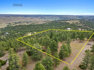


tbd Wild Turkey Ridge RoadColumbus, MT 59019
Other · Stillwater County
Description
Owner financing available! Escape to the hills of Montana and enjoy country living with 21 plus ACRES OF PRIVACY! This property in the Pine Hills 30 miles west of Billings and just north of the Yellowstone River offers lots of seclusion and privacy. This property offers great views of the Pryor Mountains to the east and glimpses of the Beartooth Mountains to the south. The property has a mix of topography with some very steep areas that drop towards the north where you will find some great build sites among the pine trees. 2/3 of the land was burnt years ago, so some areas could be developed for pasture. Power is about 1/2 mile away, so solar would be the more affordable option. Phone lines are along the road, but Cell phones work. It is only 5 miles off the state highway, 30 miles west of Billings and 14 miles east of Columbus or 12 miles west of Park City. Wildlife here includes deer, elk, turkeys, grouse and antelope. The HOA plows and maintains the roads, so it works well for year-round living. There are covenants in place to protect your property values, plus owning land here gives you access to a 20 acre private park on the Yellowstone River with a BBQ, picnic tables, gazebo and access to fishing a blue ribbon trout water! Only an hour from Red Lodge for skiing and 2 hours from Yellowstone National Park! Call for more details and to set up a showing! Owner is willing to finance with as little as 10% down.
Property Information
- Property type
- Land
- Sub-type
- Unimproved Land
- Lot size
- 21.88 acres
- Days on market
- 184
- MLS® Listing#
- 410844
Property Features
- Lot features
- Sloped · Level · Rolling Slope
- Utilities
- Natural Gas Not Available · Phone Available
Financial Details
- HOA
- $300 / Annually
- Annual taxes
- $80Tax year 2025
- Parcel number
- 0001020808
Directions
East of Columbus on Hwy 10 for 9.3 miles, Turn left onto Pine Crest Rd and follow for 4.5 miles. Turn right onto Wild Turkey Ridge and go 1/2 mile where road turns steep and sign. Call for map